Author Topic: NE NSW/SEQLD Showers storms 18-22 Jan 2011  (Read 17013 times)

0 Members and 1 Guest are viewing this topic.

Offline Jimmy Deguara

  • Australian and Tornado Alley storm chaser
  • Administrator
  • Wedge tornado F5
  • *
  • Posts: 2,218
  • Gender: Male
  • Storm Chaser since 1993, Tornado Alley 2001
    • Australia Severe Weather
RE: NE NSW/SEQLD Showers storms 18-22 Jan 2011
« Reply #15 on: 22 January 2011, 11:25:29 PM »
Hi guys,

Here is a video from the Dorrigo possible supercell.

Dorrigo Hailstorm 19th January 2011

Regards,

Jimmy Deguara
-------------------------------------
Australian Severe Weather
www.australiasevereweather.com

Australian Thunderbolt Tours
www.thunderbolttours.com

Phone  0408 020468  (International :  61  2  408 020468)

Offline Jimmy Deguara

  • Australian and Tornado Alley storm chaser
  • Administrator
  • Wedge tornado F5
  • *
  • Posts: 2,218
  • Gender: Male
  • Storm Chaser since 1993, Tornado Alley 2001
    • Australia Severe Weather
Re: NE NSW/SEQLD Showers storms 18-22 Jan 2011
« Reply #16 on: 23 January 2011, 05:21:36 PM »
Storm Chase 22nd January 2011

I decided to head down to near Cooma early. Storms did develop but they were ordinary and high based. It was anticipated that moisture would be in the area by say 2pm. After exploring one of the cells on the hills, I left it and head back south of Cooma. There were storms to the north along the eastern range and of course struggling cells to the south.

One cell exploded as the moisture fed into the base. Te transition into an organised cell was rapid with inflow features observed. There were two cells that seem to be on the same line. But it was the front cell that dominated. During this period, the northeast inflow was fresh and persistent. Eventually this cell began to weaken though perhaps due to loss of sufficient heating being there too many anvils.

I gradually headed north keeping watch of any cell but all cells were way too high based. On the way back and just prior to Goulburn, I observed drifts of hail measured to about 2cm.

The followig is a sequence of images of this cell


Regards,

Jimmy Deguara
« Last Edit: 23 January 2011, 05:36:21 PM by Jimmy Deguara »
-------------------------------------
Australian Severe Weather
www.australiasevereweather.com

Australian Thunderbolt Tours
www.thunderbolttours.com

Phone  0408 020468  (International :  61  2  408 020468)

Offline Lightning Chaser

  • Rope Tornado F0
  • *
  • Posts: 5
Re: NE NSW/SEQLD Showers storms 18-22 Jan 2011
« Reply #17 on: 23 January 2011, 09:10:53 PM »
here's some very brief video highlights of both friday's chase to eden/bega/moruya , and also saturdays chase with pingtang between braidwood and goulburn.

SE NSW STORMS JAN 21,22 2011

Offline Jimmy Deguara

  • Australian and Tornado Alley storm chaser
  • Administrator
  • Wedge tornado F5
  • *
  • Posts: 2,218
  • Gender: Male
  • Storm Chaser since 1993, Tornado Alley 2001
    • Australia Severe Weather
Re: NE NSW/SEQLD Showers storms 18-22 Jan 2011
« Reply #18 on: 24 January 2011, 06:32:21 AM »
I am glad somebody chased that lightning fest the other day. And the structure on that storm I assume on the way to Goulburn looks nice and consolidated!

Great stuff!

Here is the video of the Nimmitabel severe structured storm.

Structured severe storm Nimmitabel

Regards,

Jimmy Deguara
-------------------------------------
Australian Severe Weather
www.australiasevereweather.com

Australian Thunderbolt Tours
www.thunderbolttours.com

Phone  0408 020468  (International :  61  2  408 020468)

Offline Harley Pearman

  • Barrel tornado F4
  • *
  • Posts: 584
Re: NE NSW/SEQLD Showers storms 18-22 Jan 2011
« Reply #19 on: 24 January 2011, 11:10:22 AM »
Storm chase Moss Vale / Goulburn / Crookwell 22/1/2011

Saturday afternoon, I chased storms around Moss Vale on the Southern Highlands. Storms developed around Moss Vale not long after midday.

There were three storm cells that developed with one to the south, one to the south west and one to the west. The one to the west appeared weak and struggled to consolidate. The one to the south west looked more interesting but the one to the south as seen in my photos below was the most interesting. After taking the photos, I chased it to Bundanoon where I was able to sample the core and mainly heavy rainfall. I did notice that in rural areas just west of Bundanoon, allot of rain had fallen due to the amount of water on and off to the side of the road.

The storms eventually collapsed and looking south, I was aware of another storm. I then drove south to Goulburn where I intercepted a storm coming up from the south. I went up to Anzac Hill Lookout and watched the storm develop further and took some great photos. On separate threads, I am going to post photos of structure. I post a photo of what appears to be a funnel cloud although can someone please comment on the photos and try and determine what was going on and what I was looking at.

I then decided to intercept this storm by travelling north west on the Crookwell Road. North west of Goulburn,I intercepted the core of this storm and some torrential rain that made driving tough. I was reduced to 30 km/h at times due to rainfall. I had two bursts of hail although relatively small, I did pass a locality where there were hail drifts although I could not get out of the car to verify the size. The hail looked small and I would have to estimate from pea size to 2 cm or under. The rain was too heavy and there was too much water on the side of the road to stop anywhere that was safe. I did experience high winds at times and bark and leaves were being stripped off trees.

It appears there was a second storm just to the north of the first storm. I drove into it with more torrential rain and water cascading over the road at times. There was cloud to ground lightning and I experienced another burst of hail, again roughly similar in size to the first storm. I made it to Crookwell where I saw allot of water over the roads. I then drove north east to a tiny township called Laggan where my chase came to an end due to a flooded road. The storm cell rapidly went into decline. I was content and after taking photos of the flooded road, I decided to make my return trip back to Sydney via Goulburn.
  
The photos of the Moss Vale storm are attached below. The photos of the storm at Goulburn are attached on separate posts.

Harley Pearman

Offline Harley Pearman

  • Barrel tornado F4
  • *
  • Posts: 584
Re: NE NSW/SEQLD Showers storms 18-22 Jan 2011
« Reply #20 on: 24 January 2011, 11:26:32 AM »
Photos of Goulburn Storm 22/1/2011

Please find attached a sequence of photos that I took from Anzac Hill at Goulburn Looking south west. I am not sure what was going on. Any comments? In photo number 4, there appears to be a funnel on the left hand side below the base of the storm. I did note that this part of the storm had a rain free base for a while. I did see clouds forming and merging into the base. I did not see any lightning in this part of the storm while watching this. I took numerous photos for my curiosity and I post 8 photos for viewing.

Regards


Harley Pearman

Offline Harley Pearman

  • Barrel tornado F4
  • *
  • Posts: 584
Re: NE NSW/SEQLD Showers storms 18-22 Jan 2011
« Reply #21 on: 24 January 2011, 11:31:31 AM »
Goulburn storm (Final four photos 22/1/2011

The final photos of the same storm are attached. I can only place four per post due to the resolution of my photos.

Regards


Harley Pearman

Offline Jimmy Deguara

  • Australian and Tornado Alley storm chaser
  • Administrator
  • Wedge tornado F5
  • *
  • Posts: 2,218
  • Gender: Male
  • Storm Chaser since 1993, Tornado Alley 2001
    • Australia Severe Weather
Re: NE NSW/SEQLD Showers storms 18-22 Jan 2011
« Reply #22 on: 24 January 2011, 12:07:32 PM »
Hi Harley,

Absolutely awesome structure there! I am glad you got in front of the storm and let us know what it looked like. Nice striations there.

There is a feature in the 4th photograph - can you post a timelapsed video? Otherwise, did you see any rotation? How long did it last? This feature is behind the gust front and seems to be rsulting from cold outflow.

(Harley, you can reduce the resolution of the pictures for web viewing 900 x 600 and small file sizes).
« Last Edit: 24 January 2011, 12:25:42 PM by Jimmy Deguara »
-------------------------------------
Australian Severe Weather
www.australiasevereweather.com

Australian Thunderbolt Tours
www.thunderbolttours.com

Phone  0408 020468  (International :  61  2  408 020468)

Offline Michael Thomas

  • Elephant Trunk F2
  • *
  • Posts: 172
  • Gender: Male
Re: NE NSW/SEQLD Showers storms 18-22 Jan 2011
« Reply #23 on: 24 January 2011, 01:15:59 PM »
Excellent structure on the Goulburn storm. I used to like heading out to the lookout in Goulburn and watching the development from there. Interesting feature in photo four. It does look like a small funnel but the position of it seems a bit funny to me. Looks like there is some strong outflow directly below the possible funnel. Can really see the precipitation getting blown sideways in quite a few of those photos. Were damaging winds reported anywhere from this storm?

Offline Harley Pearman

  • Barrel tornado F4
  • *
  • Posts: 584
Re: NE NSW/SEQLD Showers storms 18-22 Jan 2011
« Reply #24 on: 24 January 2011, 01:28:17 PM »
Goulburn storm 22/1/2011

Thank you Jimmy.

I did not take any video of this although I was trying to get lightning from another part of the storm by taking short video snippets earlier. The structure seen I found most unusual and I was amazed. The whole base did not appear to show rotation and the lowerings and ramparts were brief to say the least. In many cases, I was lucky to get one photo. Photo 4 - I could only obtain one photo. It was brief too. Looking at it, it appears to be a funnel or something but it was not sustained for too long.

In much of this, I was noticing cloud building below the base, then briefly rotate before merging into the base. I was timing my photos to get the best I could. I was able to photograph the whole event. I did see a shelf cloud push north towards me ahead of the rain to the east of this structure but it was not significant. I also noticed that once the shelf cloud raced toward me, much of the storm was in decay except the north west portion.

Another feature of this storm is that I was hearing constant thunder rumbling from the anvil shield near and above me. This was continuing even when I left to chase it.

However this structure started to end just as I was leaving Anzac Hill. There was a second storm to the north west that was travelling north. It appears that the north west portion of this storm came too close to that other storm and eventually merged with it. I did experience two storms between Goulburn and Crookwell that were very close together with only a brief break in between and both produced hail.

It certainly showed some great structure and proved to be a significant storm in terms of the weather conditions I experienced along the Crookwell Road towards Crookwell.


Harley Pearman  

Offline James

  • Elephant Trunk F2
  • *
  • Posts: 149
  • Gender: Male
    • Sydney Storm Chasers
Re: NE NSW/SEQLD Showers storms 18-22 Jan 2011
« Reply #25 on: 24 January 2011, 02:23:28 PM »
Wow there is some great images and videos from the last few days. LC, Harley and Jimmy - awesome stuff! Jimmy the Nimmatabel video timelapse has some lovely structure. Looks like a nice bit of rotation in the low-mid levels half way through too.

Offline pingtang

  • Multi-vortex F1
  • *
  • Posts: 70
  • Gender: Male
    • Southcoastweather
Re: NE NSW/SEQLD Showers storms 18-22 Jan 2011
« Reply #26 on: 24 January 2011, 04:32:47 PM »
Some great photos and reports, well done!!!  The original plan today was to head further down the coast well west of Bega, but a last minute decision saw us heading towards Braidwood( slack shear was the main reason behind this decison).

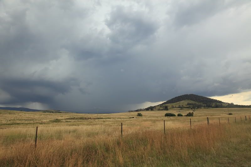
Our first storm of the day occured west of Araluan where we witnessed a scrappy line from a distance.This chucked out the occasional distant CG but little else. This line died gradually but a rain free base on the northern edge of it caught our attention.

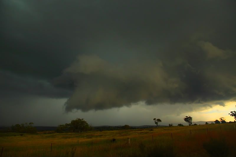
This RFB transformed from base to duluge in a matter of minutes This was taken 2kms south of Braidwood just as the storm was becoming organised. To the right you can see another RFB which was the beginnings of the Braidwood to Nerriga storm. To the left is what I suspect the right mover.


We headed towards Bungendore. We pulled over 10kms northwest of Braidwood and grabbed some more footage. Heaps of pulsating cgs were available at this stage as well as a brief wall cloud and inflow bands. There appeared to be some rotation in the base at one stage.

We hit the road again and this was the view as we headed towards Bungendore!!


We continued another 5kms after this shot before pulling over and taking the shot below.


We wanted to see what was in this thing so we let the core pass overhead. Most of the time the hail was only 2cms, however we had a few minute patch where 2-4cm stones started falling.In the heat of the chase we thought a few may've been approaching 5cms, but we highly doubt this now. But I can assure you 3-4cms without any doubt, though the biggest ones were few and far between. Quite nice hail though! Was it a supercell?  I doubt it, despite showing some really nice features at times.

We the got onto another cell near Bungendore but this was much weaker. Nethertheless some nice bolts some approx 500metres away with nice thunder.

Unfortunately the Braidwood/ Bungendore area was getting cluttered by numerous cells and the atmosphere was getting de-caped. The radar revealed a big storm near Collector heading for Goulburn. We attempted to catch this storm and got within 15kms, but we were on the wrong side of the storm and never saw any structure. The storm merged into a complex of weaker storms near Crookwell where we picked up some more CGs. We also noted heaps of leaf litter north of Goulburn and some left over hailstones.

A fairly fun chase overall, but nothing too amazing.

Will post some video in the coming days.


Offline Jimmy Deguara

  • Australian and Tornado Alley storm chaser
  • Administrator
  • Wedge tornado F5
  • *
  • Posts: 2,218
  • Gender: Male
  • Storm Chaser since 1993, Tornado Alley 2001
    • Australia Severe Weather
Re: NE NSW/SEQLD Showers storms 18-22 Jan 2011
« Reply #27 on: 25 January 2011, 04:05:38 AM »
Hi Pintang,

Quote
A fairly fun chase overall, but nothing too amazing.


I think you are being hard on yourself here. This is pretty amazing with high contrast photography - photographer's and chaser's dream. I was hoping you guys got into position to show this structure! Well done - seriously! (This is the sad reality of people having to measure up because of the term 'supercell' - a good storm be it multicell or supercell from perfect position makes for an excellent frame - period!

Quote
Most of the time the hail was only 2cms, however we had a few minute patch where 2-4cm stones started falling.In the heat of the chase we thought a few may've been approaching 5cms, but we highly doubt this now.

Excellent! That is larger than from the northern cell and this cell qualifies as a possible supercell from what I can see structure wise and you said there was a storm split.

Quote
Was it a supercell?  I doubt it, despite showing some really nice features at times.
Quote

I would not doubt it at all and I think it is a contender. I have not seen radar but from the structure alone and given the conditions on the day, there was marginal environment sufficient for at least brief rotating storms. Vorticity along boundaries can be enhanced and you do have a wall cloud intwo pictures. I wish you guys would get some timelapse - even a dash moubt on this event would have been sufficient. But of course who is talking that does not have a dash mount himself.

The seocnd photo is also interesting and it seems like some inflow feature above the wall cloud feature. How long did the wall clouds last?

Anyway, excelelnt footage of a high contrast severe storm possible supercell!

Regards,

Jimmy Deguara

« Last Edit: 25 January 2011, 04:33:38 AM by Jimmy Deguara »
-------------------------------------
Australian Severe Weather
www.australiasevereweather.com

Australian Thunderbolt Tours
www.thunderbolttours.com

Phone  0408 020468  (International :  61  2  408 020468)

Offline pingtang

  • Multi-vortex F1
  • *
  • Posts: 70
  • Gender: Male
    • Southcoastweather
Re: NE NSW/SEQLD Showers storms 18-22 Jan 2011
« Reply #28 on: 25 January 2011, 05:22:29 PM »
Hey Jimmy,

Heres the radar loop from the day. It makes for some interesting viewing.

http://www.theweatherchaser.com/radar-loop/IDR403-canberra/2011-01-21-23/2011-01-22-23


Thanks for the comments!!!!!   I agree, I was a tad hard on myself. Considering I nearly targeted the Bega to Bomala reigon I should consider myself very lucky.  Im glad we got onto this cell! the Goulburn storm was covered almost completely so it was good to get onto a different cell! Its one of those storms where you look back at the footage and appreciate it even more.


Regarding that supercell/mulitcell comment, I completely agree with that.

In regards to supercell I should've said possible instead of doubtful. Given such a wall cloud,and the presence of some 4cm stones, you'd have to think its possible. I was   dubious because of the shear, but i'm well aware that supercells do occasionally occur in marginal shear enviroments.

We witnessed two separate wall clouds. The first was very brief maybe lasting a minute or two. Unfortunately theres no footage of this, as we were driving down a crappy road and it dissapated before our eyes. The second wall cloud lasted for atleast 10minutes at a conservative guess. Pics 2 and 3 show the same wall cloud,and its not far away in the first pic!

Anyway I've posted a video. Enjoy.

Regards
Michael

Possible supercell and lovely wall cloud( Braidwood, NSW)