Looking at soundings quite useful. Very strong shear to say the least. I think the following soundings are also useful.
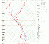
The morning sounding for Williamtown on the 29th-
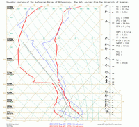
The morning sounding for Williamtown on the 30th-
The morning sounding for Rockhampton on the 30th-
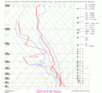
The morning sounding for Williamtown on the 29th shows quite a large elevated mixed layer with a dry adiabatic lapse rate extending from 850 to 650 hPa. The following day the William town shows 100 knots at 500 hPa, a very strong mid level jet. Finally, just for interests sake, the morning sounding for Rockhampton on the 30th shows about 1000 j/kg of CAPE and 60 knot mid level flow. I think not only the severity of this outbreak is amazing but also the coverage.
That satellite image really shows a nice isolated storm there. It would be interesting to know the distance travelled, duration and direction. If only there was radar data available.
MB edit - soundings now linked from local server.


