[Index]
Tropical Cyclone YASI
[Southern Hemisphere Summary][Summaries and Track Data]
| Tropical
Cyclones
[Index] |
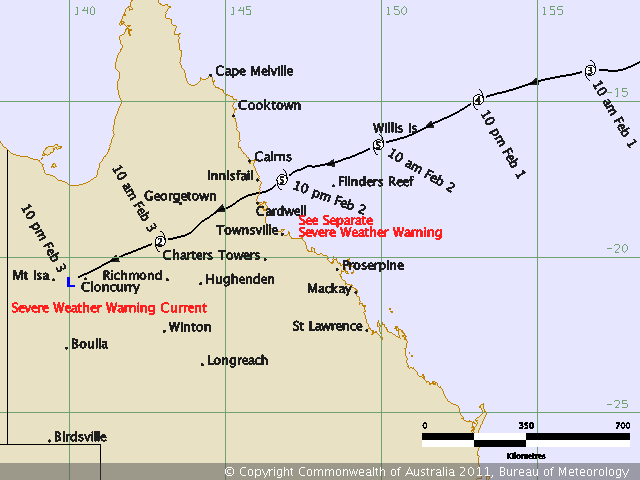
Tropical Cyclone YASI [Southern Hemisphere Summary][Summaries and Track Data] |
WTPS01 NFFN 300300
GALE WARNING 086 ISSUED FROM RSMC NADI Jan 30/0457 UTC 2011 UTC.

TROPICAL CYCLONE YASI CENTRE 995HPA CATEGORY 1 WAS LOCATED NEAR 13.4
SOUTH 169.9 EAST AT 300300 UTC.
POSITION POOR.
REPEAT POSITION 13.4S 169.9E at 300300 UTC.
CYCLONE MOVING WEST AT 7 KNOTS. CYCLONE INTENSIFYING.
EXPECT SUSTAINED WINDS OF 35 KNOTS CLOSE TO THE CENTRE INCREASING TO
45 KNOTS BY 301500 UTC.

EXPECT WINDS OVER 33 KNOTS WITHIN 150 NAUTICAL MILES IN NE QUADRANT
  AND WITHIN 150 NAUTICAL MILES IN SE QUADRANT
  AND WITHIN 100 NAUTICAL MILES IN SW QUADRANT
  AND WITHIN 100 NAUTICAL MILES IN NW QUADRANT

FORECAST POSITION NEAR 13.3S 167.7E AT 301500 UTC
              AND NEAR 13.3S 165.2E AT 310300 UTC.

ALL VESSELS WITHIN 300 NAUTICAL MILES OF CENTRE ARE REQUESTED TO SEND
REPORTS EVERY THREE HOURS TO RSMC NADI. VOS REPORTING SHIPS USE
NORMAL CHANNELS. OTHER VESSELS FAX PLUS 679 6720190 OR EMAIL NADITCC
AT MET DOT GOV DOT FJ

THIS WARNING CANCELS AND REPLACES WARNING 085.
=========================================================================
WTPS01 NFFN 300600 CCA
GALE WARNING 087 ISSUED FROM RSMC NADI Jan 30/0755 UTC 2011 UTC.

TROPICAL CYCLONE YASI CENTRE 994HPA CATEGORY 1 WAS LOCATED NEAR 13.3
SOUTH 169.3 EAST AT 300600 UTC.
POSITION POOR.
REPEAT POSITION 13.3S 169.3E at 300600 UTC.
CYCLONE MOVING WEST AT 8 KNOTS. CYCLONE INTENSIFYING.
EXPECT SUSTAINED WINDS OF 35 KNOTS CLOSE TO THE CENTRE INCREASING TO
45 KNOTS BY 301800 UTC.

EXPECT WINDS OVER 33 KNOTS WITHIN 150 NAUTICAL MILES OF CENTRE IN NE
QUADRANT
  AND WITHIN 150 NAUTICAL MILES OF CENTRE IN SE QUADRANT
  AND WITHIN 100 NAUTICAL MILES OF CENTRE IN SW QUADRANT
  AND WITHIN 100 NAUTICAL MILES OF CENTRE IN NW QUADRANT

FORECAST POSITION NEAR 13.3S 167.0E AT 301800 UTC
              AND NEAR 13.2S 164.4E AT 310600 UTC.

ALL VESSELS WITHIN 300 NAUTICAL MILES OF CENTRE ARE REQUESTED TO SEND
REPORTS EVERY THREE HOURS TO RSMC NADI. VOS REPORTING SHIPS USE
NORMAL CHANNELS. OTHER VESSELS FAX PLUS 679 6720190 OR EMAIL NADITCC
AT MET DOT GOV DOT FJ

THIS WARNING CANCELS AND REPLACES WARNING 086.
=========================================================================
WTPS01 NFFN 301200
STORM WARNING 088 ISSUED FROM RSMC NADI Jan 30/1312 UTC 2011 UTC.

TROPICAL CYCLONE YASI CENTRE 987HPA CATEGORY 1 WAS LOCATED NEAR 13.9
SOUTH 167.7 EAST AT 301200 UTC.
POSITION POOR.
REPEAT POSITION 13.9S 167.7E AT 301200 UTC.
CYCLONE MOVING WEST-SOUTHWEST AT 10 KNOTS. CYCLONE INTENSIFYING.
EXPECT SUSTAINED WINDS OF 45 KNOTS CLOSE TO THE CENTRE INCREASING TO
55 KNOTS BY 310000 UTC.

EXPECT WINDS OVER 33 KNOTS
WITHIN 150 NAUTICAL MILES OF CENTRE IN THE EASTERN SEMICIRCLE AND
WITHIN 60  NAUTICAL MILES OF CENTRE IN THE SOUTHWEST QUADRANT.

FORECAST POSITION NEAR 14.5S 165.0E AT 310000 UTC
              AND NEAR 14.6S 161.8E AT 311200 UTC.

ALL VESSELS WITHIN 300 NAUTICAL MILES OF CENTRE ARE REQUESTED TO SEND
REPORTS EVERY THREE HOURS TO RSMC NADI. VOS REPORTING SHIPS USE
NORMAL CHANNELS. OTHER VESSELS FAX PLUS 679 6720190 OR EMAIL NADITCC
AT MET DOT GOV DOT FJ

THIS WARNING CANCELS AND REPLACES WARNING 087.
=========================================================================
WTPS01 NFFN 301800
STORM WARNING 089 ISSUED FROM RSMC NADI Jan 30/1956 UTC 2011 UTC.

**** CORRECTION TO CYCLONE POSITION ******

TROPICAL CYCLONE YASI CENTRE 987HPA CATEGORY 1 WAS LOCATED NEAR 13.6
SOUTH 165.9 EAST AT 301800 UTC.
POSITION POOR.
REPEAT POSITION 13.6S 165.9E AT 301800 UTC.
CYCLONE MOVING WEST AT 13 KNOTS. CYCLONE INTENSIFYING.
EXPECT SUSTAINED WINDS OF 45 KNOTS CLOSE TO THE CENTRE INCREASING TO
55 KNOTS BY WITHIN THE NEXT 6 TO 12 HOURS.

EXPECT WINDS OVER 33 KNOTS WITHIN 150 NAUTICAL MILES OF CENTRE IN THE
EASTERN SEMICIRCLE, WITHIN 75 NAUTICAL MILES OF CENTRE IN NORTHWEST
QUADRANT AND WITHIN 60  NAUTICAL MILES OF CENTRE IN THE SOUTHWEST
QUADRANT.

FORECAST POSITION NEAR 14.5S 163.1E AT 310600 UTC
              AND NEAR 14.9S 160.3E AT 311800 UTC.

ALL VESSELS WITHIN 300 NAUTICAL MILES OF CENTRE ARE REQUESTED TO SEND
REPORTS EVERY THREE HOURS TO RSMC NADI. VOS REPORTING SHIPS USE
NORMAL CHANNELS. OTHER VESSELS FAX PLUS 679 6720190 OR EMAIL NADITCC
AT MET DOT GOV DOT FJ

THIS WARNING CANCELS AND REPLACES WARNING 088.
=========================================================================
WHPS01 NFFN 310300 CCA
HURRICANE WARNING 090  ISSUED FROM RSMC NADI Jan 31/0327 UTC 2011 UTC.

***** CORRECTION TO WIND RADII *****

TROPICAL CYCLONE YASI CENTRE 980HPA CATEGORY 2 WAS LOCATED NEAR 13.6 SOUTH 164.2
EAST AT 310000 UTC.
POSITION FAIR.
REPEAT POSITION 13.6S 164.2E AT 310000 UTC.
CYCLONE MOVING WEST AT 14 KNOTS. CYCLONE INTENSIFYING.

EXPECT SUSTAINED WINDS OF 55 KNOTS CLOSE TO THE CENTRE INCREASING TO 85 KNOTS IN
THE NEXT 24 HOURS.
EXPECT WINDS OVER 47 KNOTS WITHIN 50 NAUTICAL MILES OF CENTRE AND OVER
33 KNOTS WITHIN 150 NAUTICAL MILES OF CENTRE IN THE EASTERN SEMICIRCLE, WITHIN
90 NAUTICAL MILES OF CENTRE IN NORTHWEST QUADRANT AND WITHIN 150 NAUTICAL MILES
OF CENTRE IN THE SOUTHWEST QUADRANT.

FORECAST POSITION NEAR 14.0S 161.3E AT 311200 UTC
              AND NEAR 14.4S 158.4E AT 010000 UTC.

ALL VESSELS WITHIN 300 NAUTICAL MILES OF CENTRE ARE REQUESTED TO SEND REPORTS
EVERY THREE HOURS TO RSMC NADI. VOS REPORTING SHIPS USE NORMAL CHANNELS. OTHER
VESSELS FAX PLUS 679 6720190 OR EMAIL NADITCC AT MET DOT GOV DOT FJ.

THIS WARNING CANCELS AND REPLACES WARNING 089.
=========================================================================
WHPS01 NFFN 310600 CCA
HURRICANE WARNING 091  ISSUED FROM RSMC NADI Jan 31/0735 UTC 2011 UTC.

SEVERE TROPICAL CYCLONE YASI CENTRE 975HPA CATEGORY 3 WAS LOCATED NEAR 13.7
SOUTH 162.5 EAST AT 310600 UTC.
POSITION POOR.
REPEAT POSITION 13.7S 162.5E AT 310600 UTC.
CYCLONE MOVING WEST AT 17 KNOTS. CYCLONE INTENSIFYING.

EXPECT SUSTAINED WINDS OF 65 KNOTS CLOSE TO THE CENTRE INCREASING TO 90 KNOTS IN
THE NEXT 24 HOURS.
EXPECT WINDS OVER 63 KNOTS WITHIN 30 NAUTICAL MILES OF CENTRE
WINDS OVER 47 KNOTS WITHIN 60 NAUTICAL MILES OF CENTRE IN THE EASTERN SEMICIRLCE
AND WITHIN 40 NAUTICAL MILES ELSEWHERE
WINDS OVER 33 KNOTS WITHIN 200 NAUTICAL MILES OF CENTRE IN THE SECTORS FROM
NORTH THROUGH SOUTH TO WEST AND WITHIN 80 NAUTICAL MILES OF CENTRE ELSEWHERE.

FORECAST POSITION NEAR 14.1S 159.3E AT 311800 UTC
              AND NEAR 14.7S 156.3E AT 010600 UTC.

ALL VESSELS WITHIN 300 NAUTICAL MILES OF CENTRE ARE REQUESTED TO SEND REPORTS
EVERY THREE HOURS TO RSMC NADI. VOS REPORTING SHIPS USE NORMAL CHANNELS. OTHER
VESSELS FAX PLUS 679 6720190 OR EMAIL NADITCC AT MET DOT GOV DOT FJ.

THIS WARNING CANCELS AND REPLACES WARNING 090.
=========================================================================
WHPS01 NFFN 311200
HURRICANE WARNING 092  ISSUED FROM RSMC NADI Jan 31/1312 UTC 2011 UTC.

SEVERE TROPICAL CYCLONE YASI CENTRE 960HPA CATEGORY 3 WAS LOCATED NEAR 13.6
SOUTH 160.6 EAST AT 311200 UTC.
POSITION POOR.
REPEAT POSITION 13.6S 160.6E AT 311200 UTC.
CYCLONE MOVING WEST AT 17 KNOTS. CYCLONE INTENSIFYING.

EXPECT SUSTAINED WINDS OF 80 KNOTS CLOSE TO THE CENTRE INCREASING TO 90 KNOTS IN
THE NEXT 12 HOURS.
EXPECT WINDS OVER 63 KNOTS WITHIN 40 NAUTICAL MILES OF CENTRE
       WINDS OVER 47 KNOTS WITHIN 80 NAUTICAL MILES OF CENTRE IN THE SOUTHERN
       SEMICIRLCE AND WITHIN 50 NAUTICAL MILES IN THE NORTHERN SEMICIRCLE.
       WINDS OVER 33 KNOTS WITHIN 200 NAUTICAL MILES OF CENTRE IN THE
       SOUTHERN SEMICIRCLE AND WITHIN 150 NAUTICAL MILES OF CENTRE IN THE
NORTHEAST
       QUADRANT AND WITHIN 80 MILES IN THE NORTHWEST QUADRANT.

FORECAST POSITION NEAR 14.1S 157.1E AT 010000 UTC
              AND NEAR 14.8S 153.9E AT 011200 UTC.

THIS WARNING CANCELS AND REPLACES WARNING 091.

ALL VESSELS WITHIN 300 NAUTICAL MILES OF CENTRE ARE REQUESTED TO SEND REPORTS
EVERY THREE HOURS TO TCWC BRISBANE.

PRIMARY RESPONSIBILITIES FOR FUTURE WARNING ON TROPICAL CYCLONE YASI WILL REST
WITH TCWC BRISBANE.
=========================================================================
HIGH SEAS WEATHER WARNING FOR METAREA 10 ISSUED BY THE
AUSTRALIAN BUREAU OF METEOROLOGY TROPICAL CYCLONE WARNING CENTRE BRISBANE
AT 1913UTC 31 JANUARY 2011

HURRICANE FORCE WIND WARNING FOR NORTH EASTERN AREA

SITUATION
At 1800 UTC Severe Tropical Cyclone Yasi was centred within 35 nautical miles of
 latitude thirteen decimal six south (13.6S)
 longitude one hundred and fifty eight decimal four east (158.4E)
Recent movement : west at 22 knots
Maximum winds   : 85 knots
Central pressure: 960 hPa

AREA AFFECTED
Within 220 nautical miles in NE quadrant
  and within 300 nautical miles in SE quadrant
  and within 300 nautical miles in SW quadrant
  and within 160 nautical miles in NW quadrant.

FORECAST
Maximum winds to 85 knots near the centre increasing to 100 knots by 1800 UTC
01 February.

Winds above 64 knots within 70 nautical miles in NE quadrant
  and within 100 nautical miles in SE quadrant
  and within 90 nautical miles in SW quadrant
  and within 30 nautical miles in NW quadrant with phenomenal seas.

Winds above 48 knots within 110 nautical miles in NE quadrant
  and within 150 nautical miles in SE quadrant
  and within 140 nautical miles in SW quadrant
  and within 60 nautical miles in NW quadrant with high to very high seas and
moderate to heavy swell.

Winds above 34 knots within 220 nautical miles in NE quadrant
  and within 300 nautical miles in SE quadrant
  and within 300 nautical miles in SW quadrant
  and within 160 nautical miles in NW quadrant with very rough seas and
moderate to heavy swell.


Forecast positions
At 0600 UTC 01 February: Within 65 nautical miles of 14.3 south 154.9 east
                        Central pressure 949 hPa.
                        Winds to 95 knots near centre.
At 1800 UTC 01 February: Within 95 nautical miles of 15.4 south 151.5 east
                        Central pressure 944 hPa.
                        Winds to 100 knots near centre.

REMARKS
All ships in the area please send weather reports every three hours. Regular
weather observing ships use normal channels. Other ships please use either
email to [email protected] or fax to +61732200221 or satellite to SAC 1241
through Land Earth Station Perth 212.

Next warning will be issued by 0100 UTC 01 February 2011.

WEATHER BRISBANE
=========================================================================
HIGH SEAS WEATHER WARNING FOR METAREA 10 ISSUED BY THE
AUSTRALIAN BUREAU OF METEOROLOGY TROPICAL CYCLONE WARNING CENTRE BRISBANE
AT 0121UTC 1 FEBRUARY 2011

HURRICANE FORCE WIND WARNING FOR NORTH EASTERN AREA

SITUATION
At 0000 UTC Severe Tropical Cyclone Yasi was centred within 30 nautical miles of
 latitude fourteen decimal zero south (14.0S)
 longitude one hundred and fifty six decimal seven east (156.7E)
Recent movement : west at 18 knots
Maximum winds   : 85 knots
Central pressure: 960 hPa

AREA AFFECTED
Within 180 nautical miles in NE quadrant
  and within 250 nautical miles in southern quadrants
  and within 120 nautical miles in NW quadrant.

FORECAST
Maximum winds to 85 knots near the centre increasing to 100 knots by 0000 UTC
02 February.

Winds above 64 knots within 70 nautical miles in NE quadrant
  and within 40 nautical miles in southern quadrants
  and within 30 nautical miles in northern quadrants with phenomenal seas.

Winds above 48 knots within 50 nautical miles in NE quadrant
  and within 70 nautical miles in SE quadrant
  and within 70 nautical miles in SW quadrant
  and within 50 nautical miles in NW quadrant with very rough to high seas and
heavy swell

Winds above 34 knots within 140 nautical miles in NE quadrant
  and within 200 nautical miles in SE quadrant
  and within 200 nautical miles in SW quadrant
  and within 110 nautical miles in NW quadrant with rough to very rough seas
and moderate to heavy swell.


Forecast positions
At 1200 UTC 01 February: Within 50 nautical miles of 14.6 south 153.0 east
                        Central pressure 950 hPa.
                        Winds to 90 knots near centre.
At 0000 UTC 02 February: Within 80 nautical miles of 15.8 south 149.6 east
                        Central pressure 944 hPa.
                        Winds to 100 knots near centre.

REMARKS
All ships in the area please send weather reports every three hours. Regular
weather observing ships use normal channels. Other ships please use either
email to [email protected] or fax to +61732200221 or satellite to SAC 1241
through Land Earth Station Perth 212.

Next warning will be issued by 0700 UTC 01 February 2011.

WEATHER BRISBANE
=========================================================================
HIGH SEAS WEATHER WARNING FOR METAREA 10 ISSUED BY THE
AUSTRALIAN BUREAU OF METEOROLOGY TROPICAL CYCLONE WARNING CENTRE BRISBANE
AT 0719UTC 1 FEBRUARY 2011

HURRICANE FORCE WIND WARNING FOR NORTH EASTERN AREA

SITUATION
At 0600 UTC Severe Tropical Cyclone Yasi was centred within 30 nautical miles of
 latitude fourteen decimal four south (14.4S)
 longitude one hundred and fifty four decimal nine east (154.9E)
Recent movement : west southwest at 18 knots
Maximum winds   : 85 knots
Central pressure: 960 hPa

AREA AFFECTED
Within 160 nautical miles in northern semi-circle
  and within 250 nautical miles in southern semi-circle


FORECAST
Maximum winds to 85 knots near the centre increasing to 105 knots by 0600 UTC
02 February.

Winds above 64 knots within  30 nautical miles in northern semi-circle
  and within 40 nautical miles in southern semi-circle with phenomenal seas.

Winds above 48 knots within 70 nautical miles in northern semi-circle
  and within 90 nautical miles in southern semi-circle with very rough to high
seas and heavy swell

Winds above 34 knots within 160 nautical miles in northern semi-circle
  and within 250 nautical miles in southern semi-circle with rough to very
rough seas and moderate to heavy swell.


Forecast positions
At 1800 UTC 01 February: Within 50 nautical miles of 15.4 south 151.3 east
                        Central pressure 950 hPa.
                        Winds to 90 knots near centre.
At 0600 UTC 02 February: Within 80 nautical miles of 16.5 south 147.8 east
                        Central pressure 937 hPa.
                        Winds to 105 knots near centre.

REMARKS
All ships in the area please send weather reports every three hours. Regular
weather observing ships use normal channels. Other ships please use either
email to [email protected] or fax to +61732200221 or satellite to SAC 1241
through Land Earth Station Perth 212.

Next warning will be issued by 1300 UTC 01 February 2011.

WEATHER BRISBANE
=========================================================================
HIGH SEAS WEATHER WARNING FOR METAREA 10 ISSUED BY THE
AUSTRALIAN BUREAU OF METEOROLOGY TROPICAL CYCLONE WARNING CENTRE BRISBANE
AT 1302UTC 1 FEBRUARY 2011

HURRICANE FORCE WIND WARNING FOR NORTH EASTERN AREA

SITUATION
At 1200 UTC Severe Tropical Cyclone Yasi was centred within 20 nautical miles of
 latitude fifteen decimal zero south (15.0S)
 longitude one hundred and fifty three decimal one east (153.1E)
Recent movement : west southwest at 18 knots
Maximum winds   : 100 knots
Central pressure: 940 hPa

AREA AFFECTED
Within 160 nautical miles in northern semi-circle
  and within 250 nautical miles in southern semi-circle


FORECAST
Maximum winds to 100 knots near the centre increasing to 105 knots by 1800 UTC
01 February.

Winds above 64 knots within  30 nautical miles in northern semi-circle
  and within 40 nautical miles in southern semi-circle with phenomenal seas.

Winds above 48 knots within 90 nautical miles in northern semi-circle
  and within 120 nautical miles in southern semi-circle with very rough to high
seas and heavy swell

Winds above 34 knots within 160 nautical miles in northern semi-circle
  and within 250 nautical miles in southern semi-circle with rough to very
rough seas and moderate to heavy swell.


Forecast positions
At 0000 UTC 02 February: Within 50 nautical miles of 16.1 south 149.6 east
                        Central pressure 937 hPa.
                        Winds to 105 knots near centre.
At 1200 UTC 02 February: Within 80 nautical miles of 17.1 south 146.0 east
                        Central pressure 937 hPa.
                        Winds to 105 knots near centre.

REMARKS
All ships in the area please send weather reports every three hours. Regular
weather observing ships use normal channels. Other ships please use either
email to [email protected] or fax to +61732200221 or satellite to SAC 1241
through Land Earth Station Perth 212.

Next warning will be issued by 1900 UTC 01 February 2011.

WEATHER BRISBANE
=========================================================================
HIGH SEAS WEATHER WARNING FOR METAREA 10 ISSUED BY THE
AUSTRALIAN BUREAU OF METEOROLOGY TROPICAL CYCLONE WARNING CENTRE BRISBANE
AT 2048UTC 1 FEBRUARY 2011

HURRICANE FORCE WIND WARNING FOR NORTH EASTERN AREA

SITUATION
At 1800 UTC Severe Tropical Cyclone Yasi was centred within 10 nautical miles of
 latitude fifteen decimal seven south (15.7S)
 longitude one hundred and fifty one decimal seven east (151.7E)
Recent movement : west southwest at 15 knots
Maximum winds   : 115 knots
Central pressure: 924 hPa

AREA AFFECTED
Within 190 nautical miles in northern semi-circle
  and within 280 nautical miles in southern semi-circle (corrected)


FORECAST
Maximum winds to 115 knots near the centre.

Winds above 64 knots within  30 nautical miles in northern semi-circle
  and within 50 nautical miles in southern semi-circle with phenomenal seas.

Winds above 48 knots within 90 nautical miles in northern semi-circle
  and within 130 nautical miles in southern semi-circle with very rough to high
seas and heavy swell

Winds above 34 knots within 190 nautical miles in northern semi-circle
  and within 280 nautical miles in southern semi-circle with rough to very
rough seas and moderate to heavy swell.


Forecast positions
At 0600 UTC 02 February: Within 50 nautical miles of 16.8 south 148.1 east
                        Central pressure 924 hPa.
                        Winds to 115 knots near centre.
At 1800 UTC 02 February: Within 80 nautical miles of 17.9 south 144.7 east
                        Central pressure 976 hPa.
                        Winds to 65 knots near centre.

REMARKS
All ships in the area please send weather reports every three hours. Regular
weather observing ships use normal channels. Other ships please use either
email to [email protected] or fax to +61732200221 or satellite to SAC 1241
through Land Earth Station Burum 212.

Next warning will be issued by 0100 UTC 02 February 2011.

WEATHER BRISBANE
=========================================================================
HIGH SEAS WEATHER WARNING FOR METAREA 10 ISSUED BY THE
AUSTRALIAN BUREAU OF METEOROLOGY TROPICAL CYCLONE WARNING CENTRE BRISBANE
AT 0105UTC 2 FEBRUARY 2011

HURRICANE FORCE WIND WARNING FOR NORTH EASTERN AREA

SITUATION
At 0000 UTC Severe Tropical Cyclone Yasi was centred within 15 nautical miles of
 latitude sixteen decimal four south (16.4S)
 longitude one hundred and forty nine decimal nine east (149.9E)
Recent movement : west southwest at 19 knots
Maximum winds   : 115 knots
Central pressure: 922 hPa

AREA AFFECTED
Within 190 nautical miles in northern semi-circle
  and within 260 nautical miles in southern semi-circle


FORECAST
Maximum winds to 115 knots near the centre.

Winds above 64 knots within  30 nautical miles in northern semi-circle
  and within 50 nautical miles in southern semi-circle with phenomenal seas.

Winds above 48 knots within 90 nautical miles in northern semi-circle
  and within 130 nautical miles in southern semi-circle with very rough to high
seas and heavy swell

Winds above 34 knots within 190 nautical miles in northern semi-circle
  and within 260 nautical miles in southern semi-circle with rough to very
rough seas and heavy swell.


Forecast positions
At 1200 UTC 02 February: Within 45 nautical miles of 17.6 south 146.5 east
                        Central pressure 922 hPa.
                        Winds to 115 knots near centre.
At 0000 UTC 03 February: Within 75 nautical miles of 18.9 south 143.2 east
                        Central pressure 976 hPa.
                        Winds to 50 knots near centre.

REMARKS
All ships in the area please send weather reports every three hours. Regular
weather observing ships use normal channels. Other ships please use either
email to [email protected] or fax to +61732200221 or satellite to SAC 1241
through Land Earth Station Burum 212.

Next warning will be issued by 0700 UTC 02 February 2011.

WEATHER BRISBANE
=========================================================================
HIGH SEAS WEATHER WARNING FOR METAREA 10 ISSUED BY THE
AUSTRALIAN BUREAU OF METEOROLOGY TROPICAL CYCLONE WARNING CENTRE BRISBANE
AT 0635UTC 2 FEBRUARY 2011

HURRICANE FORCE WIND WARNING FOR NORTH EASTERN AREA

SITUATION
At 0600 UTC Severe Tropical Cyclone Yasi was centred within 15 nautical miles of
 latitude seventeen decimal one south (17.1S)
 longitude one hundred and forty eight decimal one east (148.1E)
Recent movement : west southwest at 19 knots
Maximum winds   : 110 knots
Central pressure: 930 hPa

AREA AFFECTED
Within 190 nautical miles in NE quadrant
  and within 240 nautical miles in SE quadrant
  and within 170 nautical miles in SW quadrant
  and within 140 nautical miles in NW quadrant.


FORECAST
Maximum winds to 110 knots near the centre.

Winds above 64 knots within  40 nautical miles in northern semi-circle
  and within 50 nautical miles in southern semi-circle with phenomenal seas.

Winds above 48 knots within 80 nautical miles in northern semi-circle
  and within 120 nautical miles in southern semi-circle with very rough to high
seas and heavy swell

Winds above 34 knots within 190 nautical miles in NE quadrant
  and within 240 nautical miles in SE quadrant
  and within 170 nautical miles in SW quadrant
  and within 140 nautical miles in NW quadrant with rough to very rough seas
and heavy swell.


Forecast positions
At 1800 UTC 02 February: Within 45 nautical miles of 18.6 south 144.5 east
                        Central pressure 951 hPa.
                        Winds to 85 knots near centre.
At 0600 UTC 03 February: Within 75 nautical miles of 19.9 south 141.3 east
                        Central pressure 984 hPa.
                        Winds to 45 knots near centre.

REMARKS
All ships in the area please send weather reports every three hours. Regular
weather observing ships use normal channels. Other ships please use either
email to [email protected] or fax to +61732200221 or satellite to SAC 1241
through Land Earth Station Burum 212.

Next warning will be issued by 1300 UTC 02 February 2011.

WEATHER BRISBANE
=========================================================================
HIGH SEAS WEATHER WARNING FOR METAREA 10 ISSUED BY THE
AUSTRALIAN BUREAU OF METEOROLOGY TROPICAL CYCLONE WARNING CENTRE BRISBANE
AT 1302UTC 2 FEBRUARY 2011

HURRICANE FORCE WIND WARNING FOR NORTH EASTERN AREA

SITUATION
At 1200 UTC Severe Tropical Cyclone Yasi was centred within 10 nautical miles of
 latitude seventeen decimal five south (17.5S)
 longitude one hundred and forty six decimal nine east (146.9E)
Recent movement : west southwest at 13 knots
Maximum winds   : 110 knots
Central pressure: 930 hPa

AREA AFFECTED
Within 190 nautical miles in NE quadrant
  and within 240 nautical miles in SE quadrant
  and within 150 nautical miles in SW quadrant
  and within 140 nautical miles in NW quadrant.


FORECAST
Maximum winds to 110 knots near the centre.

Winds above 64 knots within  35 nautical miles in northern semi-circle
  and within 50 nautical miles in southern semi-circle with phenomenal seas.

Winds above 48 knots within 80 nautical miles in northern semi-circle
  and within 120 nautical miles in southern semi-circle with very rough to high
seas and heavy swell

Winds above 34 knots within 190 nautical miles in NE quadrant
  and within 240 nautical miles in SE quadrant
  and within 150 nautical miles in SW quadrant
  and within 140 nautical miles in NW quadrant with rough to very rough seas
and heavy swell.


Forecast positions
At 0000 UTC 03 February: Within 45 nautical miles of 18.9 south 143.5 east
                        Central pressure 970 hPa.
                        Winds to 65 knots near centre.
At 1200 UTC 03 February: Within 75 nautical miles of 20.1 south 140.6 east
                        Central pressure 989 hPa.
                        Winds to 35 knots near centre.

REMARKS
All ships in the area please send weather reports every three hours. Regular
weather observing ships use normal channels. Other ships please use either
email to [email protected] or fax to +61732200221 or satellite to SAC 1241
through Land Earth Station Burum 212.

Next warning will be issued by 1900 UTC 02 February 2011.

WEATHER BRISBANE
=========================================================================
HIGH SEAS WEATHER WARNING FOR METAREA 10 ISSUED BY THE
AUSTRALIAN BUREAU OF METEOROLOGY TROPICAL CYCLONE WARNING CENTRE BRISBANE
AT 1911UTC 2 FEBRUARY 2011

GALE WARNING FOR NORTH EASTERN AREA

SITUATION
At 1800 UTC Severe Tropical Cyclone Yasi was centred within 15 nautical miles of
 latitude eighteen decimal four south (18.4S)
 longitude one hundred and forty five decimal one east (145.1E)
Recent movement : west southwest at 19 knots
Maximum winds   : 90 knots
Central pressure: 950 hPa

AREA AFFECTED
From the Queensland coast to a line 15S 145E to 16S 149E to 20S 148.5E


FORECAST
N/NE winds 34/47 knots. Rough to very rough seas and heavy swell.


Forecast positions
Severe Tropical Cyclone Yasi will continue to move westward over land and
weaken.

REMARKS
All ships in the area please send weather reports every three hours. Regular
weather observing ships use normal channels. Other ships please use either
email to [email protected] or fax to +61732200221 or satellite to SAC 1241
through Land Earth Station Burum 212.

Next warning will be issued by 0100 UTC 03 February 2011.

WEATHER BRISBANE
=========================================================================
HIGH SEAS WEATHER WARNING FOR METAREA 10 ISSUED BY THE
AUSTRALIAN BUREAU OF METEOROLOGY TROPICAL CYCLONE WARNING CENTRE BRISBANE
AT 0110UTC 3 FEBRUARY 2011

GALE WARNING FOR NORTH EASTERN AREA

SITUATION
At 0000 UTC Tropical Cyclone Yasi was centred within 30 nautical miles of
 latitude nineteen decimal five south (19.5S)
 longitude one hundred and forty two decimal nine east (142.9E)
Recent movement : west southwest at 22 knots
Maximum winds   : 50 knots over land
Central pressure: 980 hPa

AREA AFFECTED
From the Queensland coast to a line 18S 146E to 18S 148E to 20S 148E


FORECAST
NE winds 34/45 knots easing below 34 knots by 0600 UTC 3 February. Rough to
very rough seas and heavy swell.

Forecast positions
Severe Tropical Cyclone Yasi will continue to move westward over land and
weaken.

REMARKS
All ships in the area please send weather reports every three hours. Regular
weather observing ships use normal channels. Other ships please use either
email to [email protected] or fax to +61732200221 or satellite to SAC 1241
through Land Earth Station Burum 212.

Next warning will be issued by 0700 UTC 03 February 2011.

WEATHER BRISBANE
=========================================================================
HIGH SEAS WEATHER WARNING FOR METAREA 10 ISSUED BY THE
AUSTRALIAN BUREAU OF METEOROLOGY TROPICAL CYCLONE WARNING CENTRE BRISBANE
AT 0425UTC 3 FEBRUARY 2011

CANCELLATION OF GALE WARNING FOR NORTH EASTERN AREA

SITUATION
At 0300 UTC Tropical Cyclone Yasi was centred well inland within 20 nautical
miles of
 latitude nineteen decimal eight south (19.8S)
 longitude one hundred and forty two decimal one east (142.1E)
moving west southwest at 22 knots

AREA AFFECTED
From the Queensland coast to a line 18S 146E to 18S 148E to 20S 148E


FORECAST
Winds have eased below 34 knots. Heavy swell remains.

REMARKS
All ships in the area please send weather reports every three hours. Regular
weather observing ships use normal channels. Other ships please use either
email to [email protected] or fax to +61732200221 or satellite to SAC 1241
through Land Earth Station Burum 212.

No further warnings will be issued for this system.

WEATHER BRISBANE
| [Australian Severe Weather index] [Copyright Notice] [Email Contacts] [Search This Site] [Privacy Policy] | |
| Document: tropical_cyclone_yasi.htm | Updated: 16 June 2011 |