[Index]
Tropical Cyclone 201120
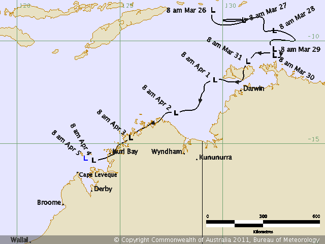
[Southern Hemisphere Summary][Summaries and Track Data]
| Tropical
Cyclones
[Index] |
Tropical Cyclone 201120 [Southern Hemisphere Summary][Summaries and Track Data] |
HIGH SEAS WEATHER WARNING FOR METAREA 10/11
Issued by the AUSTRALIAN BUREAU OF METEOROLOGY, DARWIN
Issued at 0145UTC 1 APRIL 2011

PLEASE BE AWARE
Wind gusts can be a further 40 percent stronger than the averages
given here, and maximum waves may be up to twice the height.

GALE WARNING FOR NORTHERN AREA

SITUATION
At 0000 UTC a Tropical Low was centred within 45 nautical miles of
 latitude eleven decimal nine south (11.9S)
 longitude one hundred and twenty nine decimal seven east (129.7E)
Recent movement : west at 5 knots
Maximum winds   : 25 knots
Central pressure: 1001 hPa
The low is expected to develop into a tropical cyclone in the next 18 to 24
hours.

AREA AFFECTED
Within 80 nautical miles of the centre.

FORECAST
Maximum winds to 25 knots near the centre increasing to 35 knots by 0000 UTC 02
April.
Winds above 34 knots within 80 nautical miles of centre with rough seas and
moderate swell.

Forecast positions
At 1200 UTC 01 April: Within 75 nautical miles of 12.2 south 128.7 east
                        Central pressure 999 hPa.
                        Winds to 30 knots near centre.
At 0000 UTC 02 April: Within 105 nautical miles of 12.8 south 127.5 east
                        Central pressure 996 hPa.
                        Winds to 35 knots near centre.

REMARKS
All ships in the area please send weather reports every three hours.
Regular weather observing ships use normal channels.
Other ships please use either email to [email protected] or fax to +6189203829
or satellite using SAC1241 through Land Earth Station Burum 312 [or 212 as
appropriate] via Perth.

Next warning will be issued by 0730 UTC 01 April 2011.

DARWIN Tropical Cyclone Warning Centre
=========================================================================
HIGH SEAS WEATHER WARNING FOR METAREA 10/11
Issued by the AUSTRALIAN BUREAU OF METEOROLOGY, DARWIN
Issued at 0723UTC 1 APRIL 2011

PLEASE BE AWARE
Wind gusts can be a further 40 percent stronger than the averages
given here, and maximum waves may be up to twice the height.

GALE WARNING FOR NORTHERN AREA

SITUATION
At 0600 UTC a Tropical Low was centred within 45 nautical miles of
 latitude twelve decimal two south (12.2S)
 longitude one hundred and twenty nine decimal one east (129.1E)
Recent movement : west southwest at 6 knots
Maximum winds   : 25 knots
Central pressure: 998 hPa
The low is expected to develop into a tropical cyclone in the next 18 to 24
hours.

AREA AFFECTED
Within 80 nautical miles of the centre.

FORECAST
Maximum winds to 25 knots near the centre increasing to 35 knots by 0600 UTC 02
April.
Winds above 34 knots within 80 nautical miles of centre with rough seas and
moderate swell.

Forecast positions
At 1800 UTC 01 April: Within 75 nautical miles of 12.9 south 128.0 east
                        Central pressure 1001 hPa.
                        Winds to 30 knots near centre.
At 0600 UTC 02 April: Within 105 nautical miles of 13.4 south 126.8 east
                        Central pressure 998 hPa.
                        Winds to 35 knots near centre.

REMARKS
All ships in the area please send weather reports every three hours.
Regular weather observing ships use normal channels.
Other ships please use either email to [email protected] or fax to +6189203829
or satellite using SAC1241 through Land Earth Station Burum 312 [or 212 as
appropriate] via Perth.

Next warning will be issued by 1330 UTC 01 April 2011.

DARWIN Tropical Cyclone Warning Centre
=========================================================================
HIGH SEAS WEATHER WARNING FOR METAREA 10/11
Issued by the AUSTRALIAN BUREAU OF METEOROLOGY, DARWIN
Issued at 1326UTC 1 APRIL 2011

PLEASE BE AWARE
Wind gusts can be a further 40 percent stronger than the averages
given here, and maximum waves may be up to twice the height.

GALE WARNING FOR NORTHERN AREA

SITUATION
At 1200 UTC a Tropical Low was centred within 45 nautical miles of
 latitude twelve decimal five south (12.5S)
 longitude one hundred and twenty nine decimal one east (129.1E)
Recent movement : southwest at 4 knots
Maximum winds   : 25 knots
Central pressure: 1000 hPa
The low is expected to develop into a tropical cyclone in the next 18 to 24
hours.

AREA AFFECTED
Within 80 nautical miles of the centre.

FORECAST
Maximum winds to 25 knots near the centre increasing to 35 knots by 1200 UTC 02
April.
Winds above 34 knots within 80 nautical miles of centre with rough seas and
moderate swell.

Forecast positions
At 0000 UTC 02 April: Within 75 nautical miles of 13.2 south 128.0 east
                        Central pressure 999 hPa.
                        Winds to 30 knots near centre.
At 1200 UTC 02 April: Within 105 nautical miles of 13.6 south 126.7 east
                        Central pressure 996 hPa.
                        Winds to 35 knots near centre.

REMARKS
All ships in the area please send weather reports every three hours.
Regular weather observing ships use normal channels.
Other ships please use either email to [email protected] or fax to +6189203829
or satellite using SAC1241 through Land Earth Station Burum 312 [or 212 as
appropriate] via Perth.

Next warning will be issued by 1930 UTC 01 April 2011.

DARWIN Tropical Cyclone Warning Centre
=========================================================================
HIGH SEAS WEATHER WARNING FOR METAREA 10/11
Issued by the AUSTRALIAN BUREAU OF METEOROLOGY, DARWIN
Issued at 1908UTC 1 APRIL 2011

PLEASE BE AWARE
Wind gusts can be a further 40 percent stronger than the averages
given here, and maximum waves may be up to twice the height.

GALE WARNING FOR NORTHERN AREA

SITUATION
At 1800 UTC a Tropical Low was centred within 60 nautical miles of
 latitude thirteen decimal three south (13.3S)
 longitude one hundred and twenty eight decimal eight east (128.8E)
Recent movement : south southwest at 6 knots
Maximum winds   : 25 knots
Central pressure: 999 hPa
The low is expected to develop into a tropical cyclone in the next 18 to 24
hours.

AREA AFFECTED
Within 80 nautical miles of the centre.

FORECAST
Maximum winds to 25 knots near the centre increasing to 35 knots by 1800 UTC 02
April.
Winds above 34 knots developing within 80 nautical miles of centre with rough
seas and moderate swell.

Forecast positions
At 0600 UTC 02 April: Within 90 nautical miles of 13.9 south 127.2 east
                        Central pressure 997 hPa.
                        Winds to 30 knots near centre.
At 1800 UTC 02 April: Within 120 nautical miles of 14.2 south 125.8 east
                        Central pressure 994 hPa.
                        Winds to 35 knots near centre.

REMARKS
All ships in the area please send weather reports every three hours.
Regular weather observing ships use normal channels.
Other ships please use either email to [email protected] or fax to +6189203829
or satellite using SAC1241 through Land Earth Station Burum 312 [or 212 as
appropriate] via Perth.

Next warning will be issued by 0130 UTC 02 April 2011.

DARWIN Tropical Cyclone Warning Centre
=========================================================================
HIGH SEAS WEATHER WARNING FOR METAREA 10/11
Issued by the AUSTRALIAN BUREAU OF METEOROLOGY, DARWIN
Issued at 0127UTC 2 APRIL 2011

PLEASE BE AWARE
Wind gusts can be a further 40 percent stronger than the averages
given here, and maximum waves may be up to twice the height.

GALE WARNING FOR NORTHERN AREA

SITUATION
At 0000 UTC a Tropical Low was centred within 30 nautical miles of
 latitude thirteen decimal five south (13.5S)
 longitude one hundred and twenty seven decimal six east (127.6E)
Recent movement : southwest at 8 knots
Maximum winds   : 30 knots
Central pressure: 998 hPa
The low is expected to develop into a tropical cyclone in the next 6 to 12
hours.

AREA AFFECTED
Within 80 nautical miles of the centre.

FORECAST
Maximum winds to 30 knots near the centre increasing to 35 knots by 1200 UTC 02
April.
Winds above 34 knots developing within 80 nautical miles of centre with rough
seas and moderate swell.

Forecast positions
At 1200 UTC 02 April: Within 90 nautical miles of 13.8 south 126.0 east
                        Central pressure 997 hPa.
                        Winds to 35 knots near centre.
At 0000 UTC 03 April: Within 120 nautical miles of 14.3 south 124.6 east
                        Central pressure 992 hPa.
                        Winds to 40 knots near centre.

REMARKS
All ships in the area please send weather reports every three hours.
Regular weather observing ships use normal channels.
Other ships please use either email to [email protected] or fax to +6189203829
or satellite using SAC1241 through Land Earth Station Burum 312 [or 212 as
appropriate] via Perth.

Next warning will be issued by 0730 UTC 02 April 2011.

DARWIN Tropical Cyclone Warning Centre
=========================================================================
HIGH SEAS WEATHER WARNING FOR METAREA 10 ISSUED BY THE
AUSTRALIAN BUREAU OF METEOROLOGY TROPICAL CYCLONE WARNING CENTRE PERTH
AT 0819UTC 2 APRIL 2011

GALE WARNING

Please be aware, wind gusts can be a further 40 percent stronger than the
averages given here, and maximum waves may be up to twice the height.

SITUATION
At 0600 UTC a Tropical Low was centred within 15 nautical miles of
 latitude thirteen decimal eight south (13.8S)
 longitude one hundred and twenty seven decimal zero east (127.0E)
Recent movement : west southwest at 8 knots
Maximum winds   : 30 knots
Central pressure: 995 hPa
The low is expected to develop into a tropical cyclone in the next 6 to 12
hours.

AREA AFFECTED
Within 80 nautical miles of the centre.

FORECAST
Maximum winds to 30 knots near the centre increasing to 40 knots by 1800 UTC 02
April with rough seas and moderate swell.

Forecast positions
At 1800 UTC 02 April: Within 45 nautical miles of 14.3 south 125.4 east
                        Central pressure 996 hPa.
                        Winds to 40 knots
At 0600 UTC 03 April: Within 60 nautical miles of 14.8 south 124.0 east
                        Central pressure 992 hPa.
                        Winds to 45 knots.

REMARKS
All ships in the area please send weather reports every three hours.
Regular weather observing ships use normal channels.
Other ships please use either email to [email protected] or fax to +61892632261
or satellite using SAC1241 through Land Earth Station Burum 312 [or 212 as
appropriate] via Perth.

Next warning will be issued by 1300 UTC 02 April 2011.

WEATHER PERTH
=========================================================================
HIGH SEAS WEATHER WARNING FOR METAREA 10 ISSUED BY THE
AUSTRALIAN BUREAU OF METEOROLOGY TROPICAL CYCLONE WARNING CENTRE PERTH
AT 1338UTC 2 APRIL 2011

STORM FORCE WIND WARNING

Please be aware, wind gusts can be a further 40 percent stronger than the
averages given here, and maximum waves may be up to twice the height.

SITUATION
At 1200 UTC a Tropical Low was centred within 20 nautical miles of
 latitude fourteen decimal zero south (14.0S)
 longitude one hundred and twenty six decimal six east (126.6E)
Recent movement : west southwest at 6 knots
Maximum winds   : 30 knots
Central pressure: 994 hPa
The low is expected to develop into a tropical cyclone in the next 6 to 12
hours.

AREA AFFECTED
Within 80 nautical miles of the centre.

FORECAST
Maximum winds to 30 knots near the centre increasing to 40 knots by 1800 UTC 02
April with rough seas and moderate swell.

Maximum winds increasing to 50 knots within 40 nautical miles of centre by 0600
UTC 03 April with very rough seas and moderate swell.

Forecast positions
At 0000 UTC 03 April: Within 45 nautical miles of 14.6 south 125.0 east
                        Central pressure 990 hPa.
                        Winds to 45 knots
At 1200 UTC 03 April: Within 70 nautical miles of 15.2 south 123.4 east
                        Central pressure 988 hPa.
                        Winds to 50 knots.

REMARKS
All ships in the area please send weather reports every three hours.
Regular weather observing ships use normal channels.
Other ships please use either email to [email protected] or fax to +61892632261
or satellite using SAC1241 through Land Earth Station Burum 312 [or 212 as
appropriate] via Perth.

Next warning will be issued by 1900 UTC 02 April 2011.

WEATHER PERTH
=========================================================================
HIGH SEAS WEATHER WARNING FOR METAREA 10 ISSUED BY THE
AUSTRALIAN BUREAU OF METEOROLOGY TROPICAL CYCLONE WARNING CENTRE PERTH
AT 1851UTC 2 APRIL 2011

STORM FORCE WIND WARNING

Please be aware, wind gusts can be a further 40 percent stronger than the
averages given here, and maximum waves may be up to twice the height.

SITUATION
At 1800 UTC a tropical low was centred within 20 nautical miles of
 latitude fourteen decimal two south (14.2S)
 longitude one hundred and twenty five decimal nine east (125.9E)
Recent movement : west southwest at 6 knots
Maximum winds   : 30 knots
Central pressure: 994 hPa
The low is expected to develop into a tropical cyclone in the next 6 to 12
hours.

AREA AFFECTED
Within 80 nautical miles of the centre.

FORECAST
Maximum winds to 30 knots near the centre increasing to 50 knots by 1800 UTC 03
April.

Winds above 48 knots within 40 nautical miles of centre by 1800 UTC 03 April
with very rough to high seas and moderate to heavy swell.

Winds above 34 knots within 80 nautical miles of centre by 0000 UTC 03 April
with rough to very rough seas and moderate swell.

Forecast positions
At 0600 UTC 03 April: Within 50 nautical miles of 14.8 south 124.7 east
                        Central pressure 989 hPa.
                        Winds to 45 knots
At 1800 UTC 03 April: Within 80 nautical miles of 15.4 south 123.1 east
                        Central pressure 986 hPa.
                        Winds to 50 knots.

REMARKS
All ships in the area please send weather reports every three hours.
Regular weather observing ships use normal channels.
Other ships please use either email to [email protected] or fax to +61892632261
or satellite using SAC1241 through Land Earth Station Burum 312 [or 212 as
appropriate] via Perth.

Next warning will be issued by 0100 UTC 03 April 2011.

WEATHER PERTH
=========================================================================
HIGH SEAS WEATHER WARNING FOR METAREA 10 ISSUED BY THE
AUSTRALIAN BUREAU OF METEOROLOGY TROPICAL CYCLONE WARNING CENTRE PERTH
AT 0050UTC 3 APRIL 2011

GALE WARNING

Please be aware, wind gusts can be a further 40 percent stronger than the
averages given here, and maximum waves may be up to twice the height.

SITUATION
At 0000 UTC a tropical low was centred within 30 nautical miles of
 latitude fourteen decimal six south (14.6S)
 longitude one hundred and twenty five decimal three east (125.3E)
Recent movement : west southwest at 7 knots
Maximum winds   : 25 knots
Central pressure: 998 hPa

The low is expected to develop into a tropical cyclone in the next 12 to 18
hours hours.

AREA AFFECTED
Within 80 nautical miles of the centre.

FORECAST
Maximum winds to 25 knots near the centre increasing to 40 knots by 1800 UTC 03
April.

Winds above 34 knots within 80 nautical miles of centre by 1800 UTC 03 April
with rough to very rough seas and moderate swell.

Forecast positions
At 1200 UTC 03 April: Within 60 nautical miles of 15.1 south 123.9 east
                        Central pressure 996 hPa.
                        Winds to 30 knots
At 0000 UTC 04 April: Within 90 nautical miles of 15.4 south 122.5 east
                        Central pressure 994 hPa.
                        Winds to 40 knots.

REMARKS
All ships in the area please send weather reports every three hours.
Regular weather observing ships use normal channels.
Other ships please use either email to [email protected] or fax to +61892632261
or satellite using SAC1241 through Land Earth Station Burum 312 [or 212 as
appropriate] via Perth.

Next warning will be issued by 0700 UTC 03 April 2011.

WEATHER PERTH
=========================================================================
HIGH SEAS WEATHER WARNING FOR METAREA 10 ISSUED BY THE
AUSTRALIAN BUREAU OF METEOROLOGY TROPICAL CYCLONE WARNING CENTRE PERTH
AT 0641UTC 3 APRIL 2011

GALE WARNING

Please be aware, wind gusts can be a further 40 percent stronger than the
averages given here, and maximum waves may be up to twice the height.

SITUATION
At 0600 UTC a tropical low was centred within 30 nautical miles of
 latitude fifteen decimal one south (15.1S)
 longitude one hundred and twenty four decimal nine east (124.9E)
Recent movement : southwest at 7 knots
Maximum winds   : 25 knots
Central pressure: 996 hPa

The low is expected to develop into a tropical cyclone in the next 12 hours.

AREA AFFECTED
Within 80 nautical miles of the centre.

FORECAST
Maximum winds to 25 knots near the centre increasing to 40 knots by 1800 UTC 03
April.

Winds above 34 knots within 80 nautical miles of centre by 1800 UTC 03 April
with rough to very rough seas and low to moderate swell.

Forecast positions
At 1800 UTC 03 April: Within 60 nautical miles of 15.5 south 123.6 east
                        Central pressure 994 hPa.
                        Winds to 40 knots
At 0600 UTC 04 April: Within 90 nautical miles of 15.9 south 122.0 east
                        Central pressure 992 hPa.
                        Winds to 45 knots.

REMARKS
All ships in the area please send weather reports every three hours.
Regular weather observing ships use normal channels.
Other ships please use either email to [email protected] or fax to +61892632261
or satellite using SAC1241 through Land Earth Station Burum 312 [or 212 as
appropriate] via Perth.

Next warning will be issued by 1300 UTC 03 April 2011.

WEATHER PERTH
=========================================================================
HIGH SEAS WEATHER WARNING FOR METAREA 10 ISSUED BY THE
AUSTRALIAN BUREAU OF METEOROLOGY TROPICAL CYCLONE WARNING CENTRE PERTH
AT 1252UTC 3 APRIL 2011

GALE WARNING

Please be aware, wind gusts can be a further 40 percent stronger than the
averages given here, and maximum waves may be up to twice the height.

SITUATION
At 1200 UTC a tropical low was centred within 30 nautical miles of
 latitude fifteen decimal six south (15.6S)
 longitude one hundred and twenty four decimal five east (124.5E)
Recent movement : southwest at 6 knots
Maximum winds   : 25 knots
Central pressure: 998 hPa

The low is expected to develop into a tropical cyclone in the next 12 hours.

AREA AFFECTED
Within 80 nautical miles of the centre.

FORECAST
Maximum winds to 25 knots near the centre increasing to 35 knots by 0000 UTC 04
April.

Winds above 34 knots within 80 nautical miles of centre by 0000 UTC 04 April
with rough to very rough seas and low to moderate swell.

Forecast positions
At 0000 UTC 04 April: Within 55 nautical miles of 16.0 south 123.2 east
                        Central pressure 995 hPa.
                        Winds to 35 knots
At 1200 UTC 04 April: Within 80 nautical miles of 16.3 south 121.8 east
                        Central pressure 992 hPa.
                        Winds to 45 knots.

REMARKS
All ships in the area please send weather reports every three hours.
Regular weather observing ships use normal channels.
Other ships please use either email to [email protected] or fax to +61892632261
or satellite using SAC1241 through Land Earth Station Burum 312 [or 212 as
appropriate] via Perth.

Next warning will be issued by 1900 UTC 03 April 2011.

WEATHER PERTH
=========================================================================
HIGH SEAS WEATHER WARNING FOR METAREA 10 ISSUED BY THE
AUSTRALIAN BUREAU OF METEOROLOGY TROPICAL CYCLONE WARNING CENTRE PERTH
AT 1832UTC 3 APRIL 2011

GALE WARNING

Please be aware, wind gusts can be a further 40 percent stronger than the
averages given here, and maximum waves may be up to twice the height.

SITUATION
At 1800 UTC a tropical low was centred within 30 nautical miles of
 latitude sixteen decimal zero south (16.0S)
 longitude one hundred and twenty four decimal one east (124.1E)
Recent movement : southwest at 6 knots
Maximum winds   : 25 knots
Central pressure: 1000 hPa

The low is expected to develop into a tropical cyclone in the next 12 hours.

AREA AFFECTED
Within 80 nautical miles of the centre.

FORECAST
Maximum winds to 25 knots near the centre increasing to 35 knots by 0600 UTC 04
April.

Winds above 34 knots within 80 nautical miles of centre by 0600 UTC 04 April
with rough to very rough seas and low to moderate swell.

Forecast positions
At 0600 UTC 04 April: Within 60 nautical miles of 16.4 south 123.1 east
                        Central pressure 998 hPa.
                        Winds to 35 knots
At 1800 UTC 04 April: Within 90 nautical miles of 16.7 south 121.8 east
                        Central pressure 996 hPa.
                        Winds to 40 knots.

REMARKS
All ships in the area please send weather reports every three hours.
Regular weather observing ships use normal channels.
Other ships please use either email to [email protected] or fax to +61892632261
or satellite using SAC1241 through Land Earth Station Burum 312 [or 212 as
appropriate] via Perth.

Next warning will be issued by 0100 UTC 04 April 2011.

WEATHER PERTH
=========================================================================
HIGH SEAS WEATHER WARNING FOR METAREA 10 ISSUED BY THE
AUSTRALIAN BUREAU OF METEOROLOGY TROPICAL CYCLONE WARNING CENTRE PERTH
AT 2119UTC 3 APRIL 2011

GALE WARNING

Please be aware, wind gusts can be a further 40 percent stronger than the
averages given here, and maximum waves may be up to twice the height.

SITUATION
At 2100 UTC a tropical low was centred within 30 nautical miles of
 latitude sixteen decimal zero south (16.0S)
 longitude one hundred and twenty three decimal nine east (123.9E)
Recent movement : west southwest at 5 knots
Maximum winds   : 25 knots
Central pressure: 1000 hPa

The low is expected to develop into a tropical cyclone in the next 12 hours.

AREA AFFECTED
Within 80 nautical miles of the centre.

FORECAST
Maximum winds to 25 knots near the centre increasing to 35 knots by 0900 UTC 04
April.

Winds above 34 knots within 80 nautical miles of centre by 0900 UTC 04 April
with rough to very rough seas and low to moderate swell.

Forecast positions
At 0900 UTC 04 April: Within 60 nautical miles of 16.4 south 122.8 east
                        Central pressure 998 hPa.
                        Winds to 35 knots
At 2100 UTC 04 April: Within 90 nautical miles of 16.6 south 121.5 east
                        Central pressure 994 hPa.
                        Winds to 45 knots.

REMARKS
All ships in the area please send weather reports every three hours.
Regular weather observing ships use normal channels.
Other ships please use either email to [email protected] or fax to +61892632261
or satellite using SAC1241 through Land Earth Station Burum 312 [or 212 as
appropriate] via Perth.

Next warning will be issued by 0100 UTC 04 April 2011.

WEATHER PERTH
=========================================================================
HIGH SEAS WEATHER WARNING FOR METAREA 10 ISSUED BY THE
AUSTRALIAN BUREAU OF METEOROLOGY TROPICAL CYCLONE WARNING CENTRE PERTH
AT 0124UTC 4 APRIL 2011

GALE WARNING

Please be aware, wind gusts can be a further 40 percent stronger than the
averages given here, and maximum waves may be up to twice the height.

SITUATION
At 0000 UTC a tropical low was centred within 30 nautical miles of
 latitude sixteen decimal two south (16.2S)
 longitude one hundred and twenty three decimal seven east (123.7E)
Recent movement : southwest at 5 knots
Maximum winds   : 25 knots
Central pressure: 1000 hPa

The low may develop into a tropical cyclone in the next 15 to 24 hours.

AREA AFFECTED
Within 80 nautical miles of the centre.

FORECAST
Maximum winds to 25 knots near the centre increasing to 30 knots by 1200 UTC 04
April.

Winds above 34 knots within 80 nautical miles of centre by 1800 UTC 04 April
with rough to very rough seas and low to moderate swell.

Forecast positions
At 1200 UTC 04 April: Within 55 nautical miles of 16.6 south 122.6 east
                        Central pressure 998 hPa.
                        Winds to 30 knots
At 0000 UTC 05 April: Within 80 nautical miles of 16.8 south 121.1 east
                        Central pressure 996 hPa.
                        Winds to 40 knots.

REMARKS
All ships in the area please send weather reports every three hours.
Regular weather observing ships use normal channels.
Other ships please use either email to [email protected] or fax to +61892632261
or satellite using SAC1241 through Land Earth Station Burum 312 [or 212 as
appropriate] via Perth.

Next warning will be issued by 0700 UTC 04 April 2011.

WEATHER PERTH
=========================================================================
HIGH SEAS WEATHER WARNING FOR METAREA 10 ISSUED BY THE
AUSTRALIAN BUREAU OF METEOROLOGY TROPICAL CYCLONE WARNING CENTRE PERTH
AT 0352UTC 4 APRIL 2011

GALE WARNING

Please be aware, wind gusts can be a further 40 percent stronger than the
averages given here, and maximum waves may be up to twice the height.

SITUATION
At 0300 UTC a tropical low was centred within 20 nautical miles of
 latitude fifteen decimal nine south (15.9S)
 longitude one hundred and twenty three decimal one east (123.1E)
Recent movement : west southwest at 5 knots
Maximum winds   : 20 knots reaching 20/30 knots in southern quadrants at times.
Central pressure: 1002 hPa

The low is not expected to develop into a tropical cyclone within the next 24
hours.

AREA AFFECTED
Nil.

FORECAST
Gales are no longer expected within 24 hours.

Forecast positions
At 1500 UTC 04 April: Within 55 nautical miles of 16.2 south 122.0 east
                        Central pressure 1005 hPa.
                        Winds to 20 knots reaching 20/30 knots in southern
quadrants at times.
At 0300 UTC 05 April: Within 80 nautical miles of 16.5 south 120.4 east
                        Central pressure 1004 hPa.
                        Winds to 25 knots reaching 25/30 knots in southern
quadrants at times.

REMARKS
All ships in the area please send weather reports every three hours.
Regular weather observing ships use normal channels.
Other ships please use either email to [email protected] or fax to +61892632261
or satellite using SAC1241 through Land Earth Station Burum 312 [or 212 as
appropriate] via Perth.

No further warnings will be issued unless the system intensifies.

WEATHER PERTH
| [Australian Severe Weather index] [Copyright Notice] [Email Contacts] [Search This Site] [Privacy Policy] | |
| Document: tropical_cyclone_201120.htm | Updated: 16 June 2011 |